Descripción
Amplía el plugin de WordPress Leaflet Map con los plugins Leaflet y otras funciones.
Functions
-
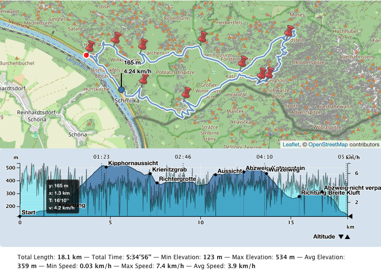
Create an elevation chart profile of a track. There are also acceleration, slope, speed and tempo chart profiles. You can also place multiple tracks on one map.
-
By default Leaflet Map uses tiles from openstreetmap.org or from the tile servers you configured. You can use more and switch between them.
-
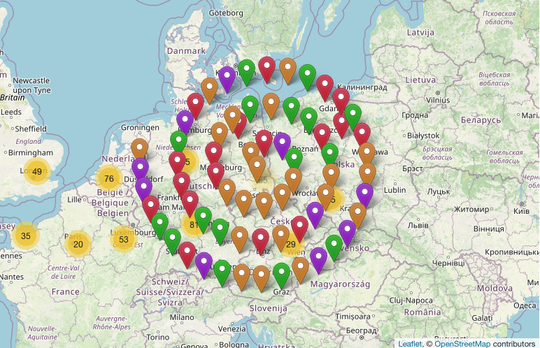
Many markers on a map become confusing. You can cluster and shape them.
-
You can use Awesome markers.
-
You can group the elements on the map by criteria and show/hide them.
-
Create a «featured map».
-
Create an overview map with geo-locations provided in the pages and posts.
-
Get a tooltip when hovering over an element.
-
You can design a choropleth map.
-
You can display the map in fullscreen mode.
-
Reset the map.
-
Gesture handling
-
Manage your files for Leaflet Map.
-
Opción para migrar de WP GPX Maps.
-
and more functions.
Included Leaflet Plugins
Leaflet Plugins
- leaflet-elevation: A Leaflet plugin that allows to add elevation profiles using d3js.
- Leaflet.GeometryUtil
- Leaflet.i18n: Internationalisation module for Leaflet plugins.
- leaflet-rotate: A Leaflet plugin that allows to add rotation functionality to map tiles
- Leaflet.AlmostOver: This plugin allows to detect mouse click and overing events on lines, with a tolerance distance.
- @tmcw/togeojson: Convert KML, GPX, and TCX to GeoJSON.
- D3: Data-Driven Documents
- Leaflet-providers: Una extensión que contiene configuraciones para varios proveedores de mosaicos.
- Leaflet.Control.Opacity: Makes multiple tile layers transparent.
- Leaflet.markercluster: Provides Beautiful Animated Marker Clustering functionality.
- Leaflet.MarkerCluster.PlacementStrategies: Styling Markerclusters.
- Leaflet.ExtraMarkers: Shameless copy of Awesome-Markers with more shapes and colors.
- Leaflet List Markers: A Leaflet Control for listing visible markers in the map.
- Leaflet.FeatureGroup.SubGroup: Grouping of Leaflet elements by options and features.
- Leaflet.Control.Layers.Tree: A Tree Layers Control for Leaflet.
- Leaflet Control Search: Search Markers/Features location by option or custom property.
- leaflet-choropleth: Choropleth plugin for Leaflet (color scale based on value).
- leaflet.zoomhome: Provides a zoom control with a «Home» button to reset the view.
- leaflet.fullscreen: Plugin sencillo para Leaflet que añade un botón de pantalla completa a tus mapas.
- Leaflet.GestureHandling: Un plugin Leaflet que permite evitar los comportamientos por defecto de scroll/toque en el mapa.
- turf: Advanced geospatial analysis for browsers and Node.js
Included Font
Documentación
Documentación detallada y ejemplos en alemán e inglés.
Thank you
Many thanks to everyone who found errors and provided ideas for new functions.
Capturas


Instalación
- Primero tienes que instalar y configurar el plugin Leaflet Map.
- Entonces instala este plugin.
- Ve a Configuración – Leaflet Map – Extensiones para Leaflet Map y obtiene la documentación y las opciones de los ajustes.
FAQ
-
Is there a widget or other support for the editor?
-
- Unfortunately both plugins – Leaflet Map and Extensions for Leaflet Map – only work with shortcodes.
- If you have any questions please ask in the forum.
-
My gpx file is not displayed!
-
- Is the URL correct?
- Does the webserver return the correct mime type (application/gpx+xml)?
Put in your.htaccess:
AddType application/gpx+xml gpx

RewriteRule .*\.gpx$ - [L,T=application/gpx+xml]
-
It doesn’t work!
-
-
Are you using any caching plugin? Try to exclude at least these js files from caching:
- /wp-content/plugins/extensions-leaflet-map/leaflet-plugins/leaflet-elevation-*
- /wp-content/plugins/extensions-leaflet-map/leaflet-plugins/leaflet-gesture-handling-*
-
Are you using any plugin to comply with the GDPR/DSGVO? There might be a problem with that.
- If you use a caching plugin and a GDPR/DSGVO plugin you need to distinguish whether the user has accepted the cookie or not.
- Please ask in the forum!
-
-
Apropos GDPR/DSGVO
-
- If you need a plugin for this try DSGVO snippet for Leaflet Map and its Extensions.
- If you use Complianz | GDPR/CCPA Cookie Consent see here.
Reseñas
Colaboradores y desarrolladores
«Extensions for Leaflet Map» es un software de código abierto. Las siguientes personas han colaborado con este plugin.
Colaboradores«Extensions for Leaflet Map» está traducido en 4 idiomas. Gracias a los traductores por sus contribuciones.
Traduce «Extensions for Leaflet Map» a tu idioma.
¿Interesado en el desarrollo?
Revisa el código , echa un vistazo al repositorio SVN o suscríbete al registro de desarrollo por RSS.
Registro de cambios
5.3 / 260619
- revised shortcode hover and the hover option opacity